New Portland, Oregon Flood Map
Floods don’t just destroy homes and carry away vehicles; they also destroy infrastructure and cut off access to the outside world, sometimes for days at a time. When shopping for a home in Portland, having the right tools at hand to understand flood risk is essential. Sometimes, it can be pretty clear that a home is directly in a flood zone where floods happen frequently. But more often, the answer is less clear-cut. First, we’ll explore the traditional way to view flood zones using FEMA and other government maps. Then, we’ll detail an exciting new tool that gives address-by-address information about flood risk.
How to View Flood Zones using FEMA and City of Portland Flood Maps
Say you’re looking at a home in John’s Landing. It’s a top-floor condo with great river views, and while most people would think they’d be safe from floods up there, you’re looking at this from a practical perspective: Just one inch of flooding on the first floor of a building can cause major damage to a property and spur mold growth for years to come. In other words, just because your living area is high and dry doesn’t mean you can’t be majorly affected by a flood.
To figure out the flood risk for this address, you first check the City of Portland’s Flood Hazard Map. By entering the address in the address bar, or just zooming into John’s Landing in South Portland, you can see that the condo building is not in the FEMA Special Flood Hazard Area. It wasn’t affected by the 1996 flood, the last major flood to hit Portland, but it was pretty close. (See our 2020 Portland Flood Risk Map blog post for detailed instructions for using this map.)
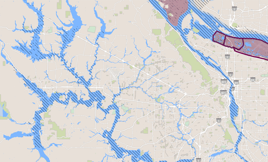
So far, so good, but you want a second opinion before purchasing this waterfront home. So you go right to the source: FEMA’s Flood Map Service Center. With an updated user interface for 2021, this flood map is also searchable, and the search bar is right at the top of the page. Scrolling down to view the map results, you can see that the flood zones are similar to what’s viewable on the Portland map, but the descriptions are a little more detailed. Just as before, the condo in John’s Landing is shown to be outside of any designated Flood Hazard zones. The nearest zone is just a few hundred feet east, along the Willamette River, where the 1996 event crested at 11 feet above flood level. The map legend describes that flood hazard zone as having a “0.2% Annual Chance Flood Hazard,” or “1% annual chance flood with average depth less than one foot or with drainage areas of less than one square mile.”
Does this home seem like a good investment? Unless you’re a flood specialist, it will probably be hard to answer that question based on the above information. It’s not that the maps are difficult to use. They just don’t answer the question, “What does it mean to live next to a flood zone?”
Get the Flood Factor, Eliminate the Guesswork
In the summer of 2020, while most of us were focused on the pandemic and wildfires that hit Oregon particularly hard, a team of scientists and data analysts from First Street Foundation unveiled a powerful new flood mapping tool. It’s designed to give property owners a realistic sense of flood risk at a hyper-local level. Flood Factor is very user-friendly and has already been endorsed by the National Association of Realtors.
Here’s why it’s a game-changer: First Street’s model uses historical flood information from FEMA and other sources and combines it with current risk factors like urban stormwater flooding and storm surges, as well as future ones such as sea level rise. Rather than display this information as “zones,” they use it to generate a “Flood Factor” number for individual addresses.
This methodology has revealed that FEMA’s numbers for how many homes are at risk for flooding are underestimated by about 70% nationwide. It also explains why property owners outside of FEMA-mapped high-risk flood areas file more than 20% of all flood insurance claims and receive 1/3 of Federal Disaster Assistance for flooding, according to the agency itself. Property owners who thought they were safe from flooding were not. Knowing the Flood Factor could help property owners prevent future disasters from occurring.
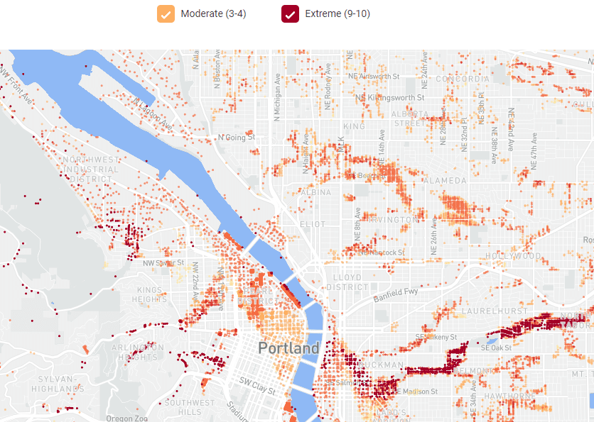
Because there is a Flood Factor available for every home in the US, Oregon, and Portland, there’s now a way to get a precise answer to the question we asked in the above example: Is there an actual flood risk for that condo in St. John’s?
Entering the address into the Flood Factor search bar pulls up a page with the Flood Factor for that property, as well as a map of the area and a graph showing the change in flood risk over time. It gives our property a Flood Factor of 4/10, or “Moderate.” This property has an 18% chance of flooding at least once in the next 30 years.
What’s Portland’s Flood Factor?
According to First Street, one-fifth of Portland properties are at risk of flooding, or about 46,000 individual homes and buildings. This represents a 177% increase over the number of homes that FEMA has found to be at risk of flooding — just over 26,000, according to the Register-Guard. That’s one of the largest discrepancies in the state.
Most properties at risk in Portland have a Flood Factor of between 3 and 6. The number takes into account the likelihood of flooding in the next 30 years, as well as the depth of flooding.
Flood Factor Matrix
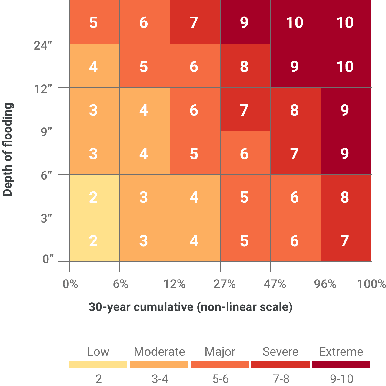
As you can see from this matrix, a Flood Factor of 3 could mean different things — a low chance of flooding up to one foot but up to a 12% chance of a less severe flood. Read more about Flood Factors here.
Search for a Home for Sale with Elevation in Mind
Most home search portals do not have elevation maps. We prefer PortlandHomesforSale.com for many reasons. It has a direct connection to the local MLS, giving it more accurate and fuller data than the national home search portals. Its dynamic real estate map is also set, on default, to show topographical elevation, so you can see at a glance if the home for sale sits on a cliff or deep in a valley (with potential flood risks).
Flood Factors and Decision-Making
As a home buyer, it’s important to consider all the risks before making an investment in a home. It’s also good to understand ways to mitigate those risks, whether by shoring up the property against potential flood or purchasing flood insurance (property owners in the City of Portland save 25% on flood insurance premiums thanks to the city’s participation in the National Flood Insurance Program’s Community Rating System (CRS)). If your home or potential home’s Flood Factor concerns you, ask your real estate agent to help you find a qualified flood risk mitigation expert.
First Street promises to update its Flood Factors quarterly as more research is conducted into flood risks across the United States. Meanwhile, Portland is working to prevent flooding from the Columbia River by shoring up the levee that protects North Portland. Read more at LeveeReadyColumbia.org
Flood Safety Tips
Now that you know the new flood scale for Portland, it’s time to talk about general flood safety tips for your home. While you may know some standard flood safety information, such as not driving through a flooded area, there are some more concrete tips to help you keep yourself and your home safe in case of flooding.
During a Flood Warning
If there is a flood watch, or a flood warning, there are some things you can do to keep your home and your family safe. First, you should gather a reasonable amount of emergency supplies. These supplies include non-perishable food and water. A good guideline is to keep 1 gallon of water a day for each person and pet in your home, and to store enough for at least three days.
If you don’t have a battery-powered radio in your home, you should invest in one, as many local updates come through radio in case the power goes out. If the power remains on, you can use your TV to check the local news.
Make sure to keep all important personal records in waterproof storage and in easily accessible places. Keep medications, medical information, passports, vaccination records, and other personal information on hand in case you need to leave your home in a hurry during flooding. You should also bring all outside furniture inside, or tie said furniture down securely.
If you do need to evacuate, turn off all utilities at the main power switch in your home, and close the main gas valve. Be prepared to leave all areas routinely subject to flooding, such as low spots, canyons, river banks, and other areas of high risk as noted on the Flood Factor Matrix for Portland.
After Flooding Happens
Once flooding happens, do not drive through or in flooded areas or areas of standing water. Your vehicle will not protect you from flood waters and can get swept away by moving water. You should never drink flood water, nor should you use it to wash your dishes, prepare food, or brush your teeth. Only use safe water for these activities. Pay attention to boil water advisories, and be sure to only used bottled, boiled, or treated water during these advisories, as you could put yourself and your family at risk for serious illness by drinking flood water. The best rule of thumb is when in doubt, throw it out. If you have food or bottled water that may have been exposed to flood water, do not drink or consume that food.
Remember, if you have been ordered to evacuate, only return home when local authorities say it is safe to do so, and follow all guidelines on how to clean your home in the case of flood damage.
Work with an Experienced Real Estate Agent
Whether you want to buy a home for the first time or are an experienced homeowner, our top 1% buyer’s agents are here to help. Likewise, if you’re considering selling a home, our top 1% seller’s agents are here to help. With 20+ years of experience in the Portland metro area, we’re here to make the entire buying or selling process smoother than ever. Give us a call at 503-714-1111 or contact the bot on our site to get started. We’d love to connect today!