Six Portland, Oregon Earthquake Maps
As with every city, Portland, Oregon doesn’t come without its hazards, one of which is the potential for earthquakes, given that our city rests on a fault line. But there are ways to deal with this particular hazard, including retrofitting your home and being prepared in the event an earthquake does happen.
Another step in managing the certainty of an earthquake in Portland is to equip yourself with resources to keep you informed. Fortunately, science is making great strides in understanding seismic changes beneath the earth’s surface and finding ways to relay what they know to the layperson. Several helpful earthquake maps exist, and we’re including them in this article. Be sure to take a look at them before you commit to buying your next home.
6. USGS Earthquake Map
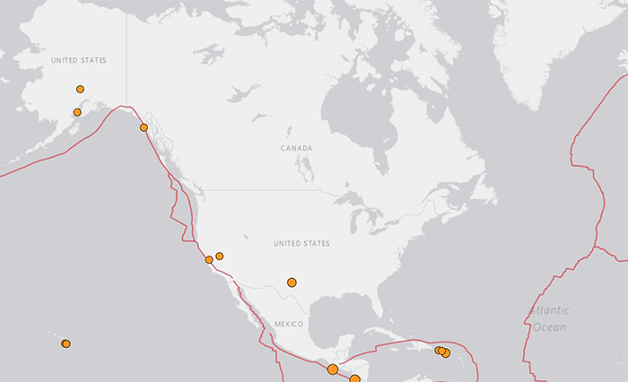
This seismic activity map, created and maintained by the U.S. Geological Survey (USGS), gives instant information about earthquakes happening around the world. Look for dots on the map and check the color legend (by clicking the key to the right) to see how recently they have happened: red is by the hour, orange is by the day, and yellow is by the week. You can also set the map to show U.S. fault lines and the degree of earthquake hazard across the country. It can be unsettling to see the degree of earthquake potential in the area where you live—Portland, Oregon rests on a very active earthquake zone, but remember that earthquakes happen all the time around the world to varying degrees, many of which do no significant damage.
5. U.S. Quaternary Faults Map
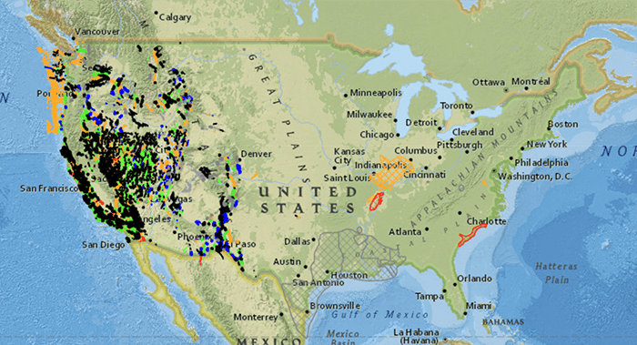
This map, also from the USGS, shows where earthquakes are likely to happen, and the data set is updated periodically, based on recent publications and information received from various states. Use the Basemap Gallery to access other maps, and zoom in on Oregon and Portland to see the various designations of earthquake possibilities in the area. To put this in perspective, though, keep in mind that quaternary faults appeared less than 1.6 million years ago: recent in geologic time, not so recent from our time reference. And in terms of those considered active, they had to have seen movement in the past 10,000 years.
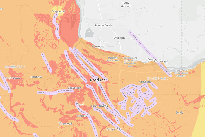
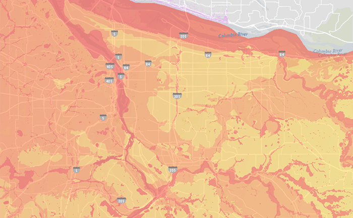
4. Oregon HazVu: Statewide Geohazards Map
This map, from the State of Oregon’s Department of Geology and Mineral Industries (DOGMI), is another that shows earthquake potential, and it gets even more specific. Use the layers feature and select the “Earthquake Hazard” option to see a color-coded layout of the Portland metro area’s earthquake hazard potential. You’ll see several active faults running through and around Portland. The area surrounding those faults, all the way to the coast, is light orange and dark orange. These colors indicate the the degree of shaking that can be expected were an earthquake to occur. How they translate: light orange = very strong, dark orange = severe. Remember, though, that these are possibilities, and “active” does not necessarily mean imminent. That said, though, it’s wise to not look the other way and important to take steps to be prepared, nevertheless.
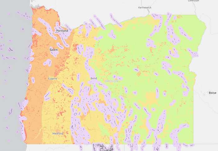
3. Portland Hills Fault Map
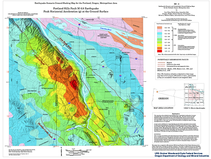
This map, also created by DOGMI, focuses on what’s known as the Portland Hills Faultline, which runs the full length of the city, north to sound, just west of the Willamette River. Also color coded, we can see that this area, especially from the Pearl District west to Cedar Mill, running all the way south to Boones Ferry back east almost to the river, lies in the dark orange range, meaning considerable damage in “specially designed structures,” leading to partial collapse. The east side of Portland is a much different story. Although there’s also a faultline that runs along the east side of the river—the East Bank Fault—we can see that the colors over here range from green (very strong shaking—negligible damage) to light aqua and dark aqua (severe shaking—slight damage).
2. Portland Geologic Hazards Map
Not all earthquake and fault maps show exactly what the hazard from an earthquake is. The USGS defines earthquake hazard as “anything associated with an earthquake that may affect the normal activities of people. This includes surface faulting, ground shaking, landslide, liquefaction, tectonic deformation, tsunamis, and seiches [a type of standing wave that occurs in closed bodies of water].”
What isn’t covered on other maps, you can find on the Portland Geologic Hazards Map, created by the Portland’s Bureau of Planning and Sustainability. Here, you’ll find two major types of information: intensity, and landslide deposits and steep slopes.
Use the Layers panel (located at the bottom of the map) to toggle between the two faults likely to hit Portland: the Portland Hills Fault and the Cascadia Subduction Zone—a 600-mile north-to-south fault that runs from northern California up to British Columbia, about 70-100 miles off the Pacific coast shoreline. You’ll see mostly orange and red, indicating the expected intensity of the shaking that will occur with both—very strong or severe effects.
If you uncheck the “Earthquake Hazards” box in the Layers panel in the “Natural Hazards” dropdown menu, you’ll find steep slopes and landslide deposits. Landslides are more prone to happen around a heavy rainstorm or earthquake, but they can occur outside those events are can be highly destructive to property. We recommend contacting a a geoengineer before you buy a home in an area with a high probability of landslides.
1. OregonLive Real-Time Earthquake Map
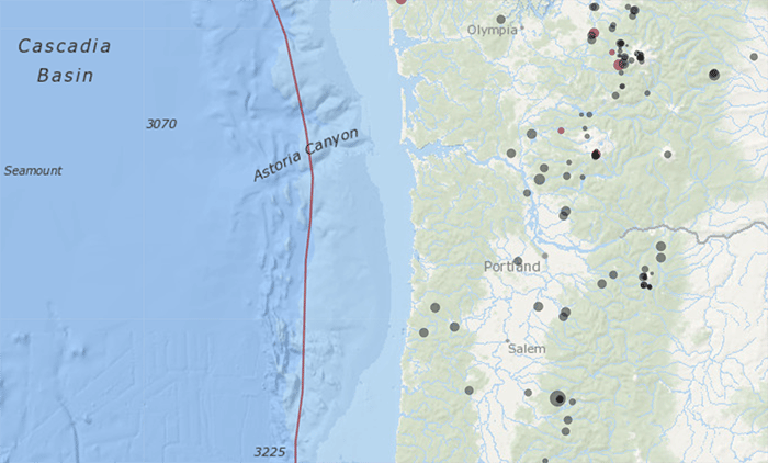
This live earthquake map draws on information from the USGS, which updates earthquake data every fifteen minutes. What sets this map apart from the others is its focus on what’s happening at the bottom of the ocean off the coast of Oregon. While ocean floor seismic activity calls up concerns of tsunamis along the coast, it can also affect Portland, depending on the strength of the quake.
Gray dots indicate earthquakes that have occurred over the past 30 days. Red dots indicate earthquakes that have occurred over the past 72 hours. Click on any dot to get information like location, date, time, and strength of the quake.
Note: This map is not intended to replace emergency tsunami alerts.
Consider Topography When Searching for a Home for Sale
While not an earthquake map, our preferred Portland home search map shows topography by default, so you can see if the home for sale you’re interested in is hanging off a cliff or sits deep in a valley.
Thinking of Buying or Selling a Home in Portland?
These maps are meant to serve as a source of information so you can make the best decision possible when it’s time for you to buy your next home. With our knowledge of the area—we’ve been helping satisfied clients buy homes in the Portland metro area for almost 20 years—and earthquake retrofitting, when necessary, you can move forward with your next real estate purchase with confidence. Call our experienced agents today: our top 1% buyer’s agents at 503-773-0000 or our top 1% seller’s agents at 503-714-1111. We look forward to connecting with you!