Top 10 Portland Neighborhoods – 2022 Report
Whether you’re moving to Portland or thinking about it, or whether you’ve lived here for a while, knowing which neighborhoods rank highest is important. Making an investment in a home is one of the biggest any of us makes in our lifetimes, so being informed about what neighborhoods have to offer will go a long way in helping you make your decision.
We looked at a variety of features in each Portland neighborhood, including highly rated schools (according to greatschools.com), shops and restaurants, as well as walk, bike, and transit scores. We also explored the history of each neighborhood to see how the past informs the present.
10. Sellwood Neighborhood
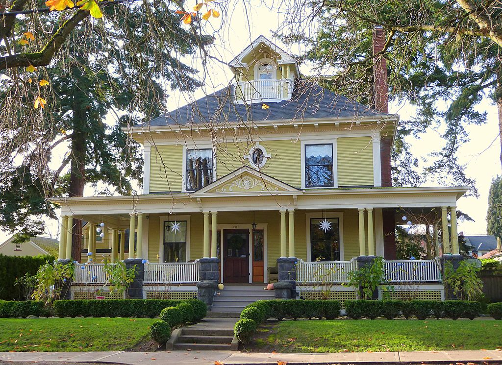
Portland’s Sellwood neighborhood may not be as trendy as other parts of Portland, but it has an obvious welcoming, small-town vibe that can make pretty much anyone feel at home. Like most Portland neighborhoods, it’s conveniently self-contained with ample grocery stores, coffee shops, restaurants, and bars. It’s also known for its wealth of antiquing options and is home to some of Portland’s first Victorians, cottages, and Craftsman bungalows.
If you like a neighborhood with quiet, tree-lined streets, perfect for strolls and connecting with neighbors, Sellwood might be your kind of place.

Sellwood History
Once a site for Native American fishing and trading encampments, the area was settled by Henderson Luelling, his brother, Alfred, and William Meek in the late 1840s. The men brought livestock and traveling nurseries to the area and established a horticultural community consisting of nurseries and fruit orchards. In fact, the three are believed to have, through their expert plant breeding, introduced many first strains to the region, the most known of which are Lambert and Bing cherries.
Sellwood went unnamed until 1866 when East Portland minister, Rev. John Sellwood, bought a 321-acre tract of land that makes up most of the community today. Intentional development of the area didn’t occur until 16 years later when Sellwood Real Estate Company bought the land. From 1887 to 1893, land holdings in Sellwood were tied up in litigation due to Sellwood Real Estate Company’s financial problems.
The Oaks Amusement Park, still functioning today, was created in 1905 to take advantage of tourist traffic brought to the area by the Lewis and Clark World’s Fair and Exposition.
By 1920, this section of Portland had grown to employ around 600, with employers being G. Schindler Co., a furniture company, East Side Mill and Lumber, East Side Box, a cardboard box manufacturing plant, Columbia Woolen Mills, and Multnomah Mohair, along with hotels, saloons, and grocery stores.
Then came the Depression, and any advances the Sellwood community had made from the 1890s was wiped out. The neighborhood experienced a short-lived rebound, thanks to the surge of industrialism prompted by World War II, but ultimately, property values in the area declined and became depressed.
Finally, in the 1970s, the revitalization of Sellwood’s old commercial district brought new businesses, most of which were focused on antiques on 13th Avenue, or Antique Row, as known by locals, many of which still thrive today.
Several of the neighborhood’s early buildings still stand, including the Bank of Sellwood, Sellwood Fire Station, the Shannon Residence, and St. Johns Episcopal Church, the oldest building in Sellwood.
Sellwood Restaurants, Bars, and Coffee Shops
As with the rest of Portland, food carts have popped up in Sellwood (Sellwood Corner Food Carts, Piknik Park Food Cart Pod, The Yellow Cart—formerly Papa Lee’s Kitchen).
- Killer Burger—Counter-service joint serving burgers with toppings like peanut butter and sriracha, plus local beer.
- Piece of Cake—Long-running cake specialist with vegan and gluten-free options, known for its quirky vibe.
- Sellwood Inn—Laid-back pub and eatery with beer garden, poker machines, darts, and pinball.
- Calabash Authentic—Fresh Calabash, Authentic West African cuisine, made daily.
- Moreland Ale House—Laid-back sports bar with Asian-inspired bites, local craft beers, weekend brunch, and outdoor seating.
- PDX Sliders—Easygoing eatery for imaginative sliders and sandwiches made with local ingredients, plus craft beers.
- Saburo’s Sushi House—Nigiri sushi and rolls are super-sized at this bustling, no-frills Japanese restaurant.
- Bastion PDX—Seasonal, sustainable plant-focused American cuisine: always gluten-free, soy-free, refined sugar-free cuisine.
- Papa Haydn—European-style desserts meet upscale American sandwiches and salads at this romantic cafe with a patio.
- Reverend’s BBQ—Fried chicken, smoked meats, and beer on tap in a contemporary space with both counter and booth seating.
- Wei Wei – A Taste of Taiwan—Creative Taiwanese noodle soups, baos, desserts, and teas in an intimate space.
- Gino’s—Modern trattoria offering carefully prepared Italian dishes and an extensive wine list in a sleek room.
- The Muddy Rudder—Laid-back pub with a kid-friendly garden patio offering pizza, sandwiches, and salads, plus live music.
- Fairlane Coffee—Specialty coffee shop using ethically sourced coffee beans, also serving tea, savory snacks, and more.
- Jade Tea House—This homey Thai and Vietnamese cafe also sells French-inspired confections like tarts and macarons.
- Backcountry Wine Tours—Customized tours to a variety of top-tier Oregon wineries.
Sellwood Points of Interest
- Sellwood Riverfront Park—7.6-acre park on the Willamette River with paths, picnic tables, restrooms, a stage, a boat dock, and an off-leash dog area.
- Westmoreland Park Nature Playground—42-acre municipal park.
- Johnson Creek City Park—4.5-acre city park named after Johnson Creek, which flows through the park.
- Oak Bottom Wildlife Refuge—141-acre city park known for attracting a wide variety of birds.
- Oaks Amusement Park—small amusement park, one of the oldest continually operating amusement parks in the country.
- Eastmoreland Golf Course—public course surrounded by parks and gardens offering lessons, a pro shop, and an eatery.
- Stars and Splendid Antique Mall—storied, sprawling business with vendors galore selling antiques, vintage jewelry, and home decor.
- Unique Antique—vintage home items, jewelry, and precious metals acquired via cash, consignment or trade.
Sellwood Rankings and Stats
- School—Sellwood Middle School – 8/10 (by greatschools.com)
- Scores—Walk: 81 / Bike: 96 / Transit: 43 (by walkscore.com)
See all Sellwood, Portland Homes for Sale
Check out our dynamic Portland neighborhood home search map.
9. Eastmoreland Neighborhood
Eastmoreland neighborhood is, without a doubt, one of the best places to live in Portland. Take a drive through this inviting and serene community on its winding streets under a canopy of mature trees, and you’ll find sprawling homes set back on expansive lawns with beautiful gardens.
Eastmoreland is almost entirely residential. You won’t find major thoroughfares with shops and restaurants here. Instead, the area is quiet and secluded, almost as if it’s a gated community. Residents take pride in maintaining well-manicured lawns and clean streets.
The neighborhood has an eclectic collection of architectural styles, including English Cottage, Colonial Revival, Tudor, and Mediterranean Revival, with a few Minimal Traditional, Ranch/Contemporary, and Craftsman/Bungalow styles.
Reed College Place is a mile-long boulevard lined with linden trees that runs down the entire north-south axis of Eastmoreland and feeds into Reed College’s main entrance at the north end. Reed College Place was established in 1910 and reflects the Ladd Estate Company’s original platting and landscape design for the neighborhood.
Reed College, founded in 1908, is considered one of the “most intellectual colleges in the country.”
Eastmoreland History
By the early twentieth century, Portland’s population had expanded to the east side of the Willamette River. Construction of the Morrison Street Bridge and the Steel Bridge in the late 1800s encouraged this expansion, as did the street improvements for vehicles and streetcar systems. In 1891, 25% of Portland’s total population lived on the east side and rose to 50% by 1910. The city’s more well-off residents were putting inner city living behind them and moving to the suburbs.
The Eastmoreland Historic District exemplifies the cohesion and continued maintenance of the aesthetics, planning, and development from the neighborhood’s early days with the combination of period style homes, open spaces, and recreation and landscape features from its three main growth periods: the City Beautiful Movement-inspired suburb period (1910-1921), the building boom with European-influenced architecture and automobile reliance period (1922-1945), and the post World War II infill period (1946-1961).
Eastmoreland reflects the early planning of Portland’s development, part of which are can be seen in the organic street networks and patterns (rather than the radial patterns we find in the Laurenhurst neighborhood), considered and created at a time when the automobile was gaining popularity. Further growth of the neighborhood and access to other parts of Portland, without the need for a streetcar system, was enabled by the construction of Ross Island Bridge in 1922.
Inspired by Frederick Law Olmstead’s focus on the Picturesque suburb, which led to the City Beautiful Movement, the Ladd Estate Company, Eastmoreland’s developer, followed suit with the intention of incorporating the neighborhood into a larger plan for the entire city. Deed restrictions were established to maintain setbacks, prohibit commercial land use, and restrict minorities from ownership. In 1926, a group of neighborhood residents bought what lots were left of the original platt, along with a 9-acre property on Eastmoreland’s south boundary, and oversaw the development of the remaining parcels, still enforcing the restrictions, which ultimately ended in 1938.
In July 1911, the Ladd Estate Company began laying tracks for a broad gauge rail line to accommodate traveling between downtown and Eastmoreland and with Reed College students in mind. The line was in full operation by March, 1912. This, along with the construction of the Eastmoreland viaduct in 1911 turned the neighborhood from “nearly isolated,” as described by F.N. Clark, Ladd Estate sales agent, to both a home base and a destination for many Portlanders. The viaduct allowed laborers and materials to get to the east side, creating jobs and savings on home construction costs for the growing middle class. An extension of the streetcar line came in August 1912 and extended to accommodate traveling to some of the more easterly neighborhoods beginning to develop at the time.
The first residence built in Eastmoreland belonged to Jacques and Amelia Reinhart, a Colonial Revival home that called to mind the early colonial origins of the U.S. In addition to the Reinhart’s Colonial Revival, Arts and Crafts, and Bungalow/Craftsman-style were most common in the neighborhood in the 1910s. By the end of 1921, the economic recession, which started in 1914 and continued until the end of World War I, had taken hold with only 45 homes erected within the neighborhood. Despite the neighborhood’s slow residential start, the first nine holes of Eastmoreland Golf Course were laid out in 1917, with all 18 holes completed by 1920.
In the mid 1920s, Eastmoreland residents started moving away from streetcar use, and any homes built here reflected this change, making room for automobiles. To appeal to a wider range of home buyers in more diverse economic brackets, the Ladd Estate Company advertised the construction of Colonial Bungalow-style homes with shared driveways and garages at a cost of about $7,500 each. Real estate developers used the anticipated Ross Island Bridge as a way to raise awareness and encourage development, citing easy access to the west side and increased property values. By November, 1927, the streetcar had been abandoned in Eastmoreland and use of the new bus line served as the mass transit solution for residents.
Soon after, the neighborhood saw a construction boom, with a wide variety of model, demonstration, and experimental homes going up during this period. When the Great Depression hit, construction slowed across the city, but not as much in Eastmoreland. From 1936-1943, construction boomed again with architectural styles becoming more streamlined and minimalist and homes becoming smaller.
By 1948, the U.S. Supreme Court declared Eastmoreland’s deed restrictions that excluded specific racial groups unconstitutional, ending their 50-year use.
After a lull, building picked up again between the late 1940s and early 1950s. Residents lobbied the city to allow a section of Eastmoreland called Berkeley Park, purchased in 1941, to be used as a 20-acre neighborhood tract. New homes sprung up on this parcel, except for 6.5 acres designated for a potential park. But in 1946, Portland Parks Superintendent deemed that even this area be used for more homes because creating and maintaining a park would be too expensive.
Residents disagreed and petitioned to keep the space as a park. To this day, Berkeley Park is a source of enjoyment for Eastmoreland residents. Two of the tennis courts have been dedicated by Geri and Jim Rovello and named after their son Alex, lost in a tragic accident in 2013. At just two years old, Alex learned to play tennis at Berkeley Park. He was a member of Cleveland High School’s only state championship team, became nationally ranked in the USTA, and was an outstanding player at the University of Oregon. Before his untimely death, he won four state singles titles.
Eastmoreland Restaurants, Bars, and Coffee Shops
While there are no restaurants, bars, or coffee shops within the boundaries of Eastmoreland, many are within walking distance in nearby neighborhoods.
Eastmoreland Points of Interest
- Berkeley Park—6.48-acre public park with a playground, fields for multiple sports, and tennis courts, among other features.
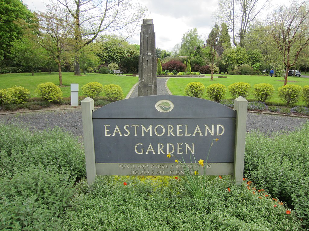
- Eastmoreland Garden—.4-acre public garden.
- Tideman Johnson City Park/Natural Area—7.7-acre city park named for a mid-19th century family named Johnson that encouraged public use of its land along the creek.
- Save the Giants Park—park created through citizen response to a developer’s bid to cut down the ancient sequoias to make room for one large house. Now safe, it is intended to be an educational space for enrichment and inspiration.
- Eastmoreland Playground Park—public park with a playground.
Eastmoreland Rankings and Stats
- School—Duniway Elementary School – 9/10 / Sellwood Middle School – 8/10 (by greatschools.com)
- Scores—Walk: 53 / Bike: 86 / Transit: 45 (by walkscore.com)
See all Eastmoreland, Portland Homes for Sale
Check out our dynamic Portland neighborhood home search map.
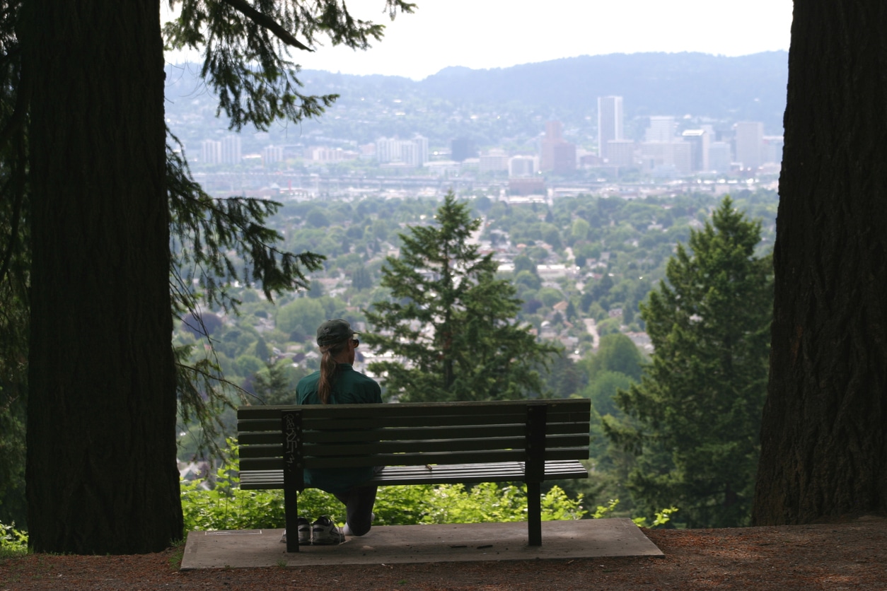
8. Mt. Tabor Neighborhood
Mt. Tabor neighborhood is made up of many nice, older homes tucked into quiet neighborhood streets around the base of Mount Tabor, which offers stunning views of the Portland skyline in the distance and beautiful wooded scenery on the way up.
Mount Tabor Park is one of the largest in Southeast Portland, and it takes up a significant portion of the neighborhood. It can be entered by car or on foot. Vehicular entrances are on 69th Avenue and Yamhill Street to the north, Harrison Street on the east, Lincoln Street on the southwest, and 60th Avenue and Salmon Street on the northwest side.
Hikers and pedestrians have multiple options for entering the park and making their way to the top of the hill, including several dead-end streets on the south side off 72nd Avenue. There are three official trails at the kiosk on the 69th and Yamhill entrance: an easy one-mile trail (Red Trail), an intermediate 1.7-mile trail (Green Trail), and a more difficult 3-mile trail (Blue Trail). The 96-step stairway between Reservoirs 5 and 6 is part of the Blue Trail, and has an optional 0.31-mile (0.5 km) loop around the summit. Feel free to ride your bike on the Red and Blue Trails. Leashed dogs are welcome on all the trails.
Today, at 636 feet, the top of Mt. Tabor is a destination for many Portlanders and visitors, which offers space for picnicking and benches for relaxing and taking in views of the city. It also has a community garden and plenty of hiking trails. You can play tennis or basketball at the courts on site, and younger kids can enjoy the playground. An off-leash dog park is located on the south side near the Harrison entrance. Restrooms are located at the summit and the visitors center near the 60th and Salmon entrance.
Life in Mt. Tabor neighborhood is quiet, yet there are some great local businesses that give it plenty of Portland character.
Mt. Tabor History
Before Portland became a city, many residential additions functioned as their own entities and even had their own post offices. Mt. Tabor was one of them, founded in the mid 1850s.
In the 1880s, the land around Mt. Tabor was deemed ideal for a water distribution system due to the hill’s elevation. Between 1894 and 1911, Mt. Tabor’s open reservoirs were created with water being piped in from the Bull Run River water shed, about 25 miles away. Their artistic designs and their accompanying gatehouses only add to the charm and experience of the park. Initially, the park had four above-ground reservoirs. The one located on SE 60th and Division was made unusable in 1980 and sold to a private developer. Its gatehouse is now a private residence.
Around the turn of the century, Mt. Tabor Park was created to maintain the beauty and serenity of the neighborhood. In 1913, a road-building crew discovered cinders in the park, evidence that the hill that overlooks the city was once an active volcano. This makes Portland one of six cities in the U.S. with an extinct volcano within the city limits. Until the construction of Forest Park in 1948, Mt. Tabor Park was the largest park in Portland.
In 2004, Mt. Tabor Park was added to the National Register of Historic Places.
Mt. Tabor Restaurants, Bars, and Coffee Shops
- La Taquiza Vegana—vegan food truck with a mission to expand the minds of others within the realm of vegan cuisine.
- Sapphire Lounge—sexy cocktail bar in a former hotel lobby serving American small plates, platters, and eclectic drinks.
- Garden Monsters—salad spot that’s raising the salad bar by using fresh, locally sourced produce, all-natural meets, and non-GMO protein alternatives. They also cater to dietary preferences and restrictions.
- Bermese Delight—food cart serving authentic Brumese cuisine.
- Matt’s BBQ Tacos—fixed-location food truck serving Texas-style BBQ and fresh tacos.
- Coquine—cozy corner kitchen serving polished, farm-to-table New American dinners and casual cafe fare by day.
- Salvi—women-owned eatery bringing authentic Salvi food to PDX.
- Bellwether Bar—cozy neighborhood bar offering warm hospitality, fine foods, classic and signature cocktails, craft beers, and natural wines.
- Tabor Bread—homey counter-serve spot crafting artisanal breads and other baked goods, along with sandwiches and coffee.
- Rain or Shine Coffee House—bright and airy coffeehouse open early for baked goods and cafe standards made from local ingredients.
- Taborspace—spacious nonprofit hangout doling out espresso drinks in a historic space with varied weekly events.
Mt. Tabor Points of Interest
- Mt. Tabor Park—large, forested century-old public park covering an extinct volcano with open-air reservoirs, tennis courts, a playground, hiking trails, and 360-degree views from the top.
Mt. Tabor Rankings and Stats
- School—Glencoe Elementary School – 8/10 / Portland Arthur Academy Charter School – 9/10 (by greatschools.com)
- Scores—Walk: 69 / Bike: 52 / Transit: 86 (by walkscore.com)
See all Mt. Tabor, Portland Homes for Sale
Check out our dynamic Portland neighborhood home search map.
7. Goose Hollow Neighborhood
Established in 1845, Goose Hollow neighborhood offers the best of both worlds: quick access to Portland’s downtown district and a stable, historic residential neighborhood. It is comprised of a mix of modern apartment complexes and 100-year-old four squares on tree-lined streets.
Providence Park is a standout in the neighborhood, host to American football when it was built in 1926, and other sports games prior to that time. Dog races, cricket, and other events, including baseball in the 1950s, have all taken place within the confines of the arena. Today, it’s home to Portland’s own soccer team, the Timbers.
Goose Hollow History
Daniel Lownsdale built the first house in Goose Hollow in 1845 on his land claim, called “The Hollow” (the North side of the neighborhood’s lower sections) and what is now Washington Park and King’s Hill. He built and operated a tannery where Multnomah Athletic Club and Providence Park stadium now sit. Amos King later bought the claim, and Lownsdale bought Francis Pettygrove’s land by the Willamette River. Thomas Carter built a house on his own land claim on the south end of the area near SW 18th and Clay, known as Carter’s Hill, what we now know as Vista Ridge.
When the neighborhood was founded, much of it was undeveloped and wild. The area surrounding Tanner Creek was a flood basin, so many of the local women raised geese there, harvesting their feathers for down. Over time, flocks started to co-mingle, which led to disputes among owners, sometime even resulting in calls to the police. The problem even made its way into the courts with threats from Judge J.F. McCoy to jail the next woman to start a fight over the geese. In reporting about the incidents, the Oregonian first used the name “Goose Hollow” to describe the neighborhood, referring only to the lower elevations of the area.
But the name was lost over decades of change and development and wasn’t resurrected until 1967 when former mayor Bud Clark opened the Goose Hollow Inn. While disagreements over geese no longer exist in the neighborhood, reminders of that time period still remain. As you walk through the neighborhood, look for images of and references to geese.
Goose Hollow Restaurants, Bars, and Coffee Shops
- 22 Below—rolled ice cream spot that also serves popping, milk, and shaken teas, along with boba smoothies.
- Vtopia All Vegan—warm, unassuming nook specializing in cashew-based cheeses, vegan sandwiches, and salads.
- Kinara Thai—neighborhood nook with contemporary decor preparing a menu of traditional Thai specialties.
- Mazatlan Mexican—colorful eatery with patio offering fresh fare and large margaritas, plus music and karaoke on weekends.
- The Soop—Korean restaurant utilizing an indoor hydroponic and microgreen farm, bringing fresh ingredients closer to your table by breaking down the old barriers set by traditional farming. In Korean, “soop” means “forest.”
- Gilda’s Italian Restaurant—happening, mural-adorned spot drawing crowds with its ample portions of traditional Italian fare.
- Gracie’s—swanky restaurant with a classic Hollywood feel serving refined American fare in the Hotel deLuxe.
- Goose Hollow Inn—venerable, laid-back tavern known for its cluttered decor and hefty Reubens, with an outdoor deck.
- The Commodore Lounge—modest neighborhood watering hole with billiards and classic American comfort food in chill surroundings.
- Kingston Sports Bar & Grill—basic sports pub in a triangular building with a pub-grub menu, many TVs, and a popular happy hour.
- Leaky Roof Gastro Pub—Cozy pub with an easygoing vibe offering a diverse menu and cocktails in a warm light-filled space.
- The Cheerful Bullpen—no-frills sports bar with individual TVs in every booth for rooting on teams like the Buffalo Bills.
- Super Joy Coffee Lab / Roasters—Asian-owned coffee roaster offering the bean with elements of Chinese culture.
Goose Hollow Points of Interest
- Frank L. Knight City Park—steep, undeveloped hillside city park next to the Vista tunnels, full of trees and bushes.
- Jefferson Street City Park—small, circular city park with evergreen and deciduous trees.
- Providence Park—sports and events venue with stadium and field hosting Major League Soccer, college football, and more.
- Multnomah Athletic Club (MAC)—private social and athletic club.
- Zupan’s Market—family-owned neighborhood gourmet grocer serving the Portland metro area with food and wine from local and global sources.
Goose Hollow Rankings and Stats
- School—Ainsworth Elementary School – 9/10 / Lincoln High School – 8/10 (by greatschools.com)
- Scores—Walk: 94 / Bike: 81 / Transit: 82 (by walkscore.com)
See all Goose Hollow, Portland Homes for Sale
Check out our dynamic Portland neighborhood home search map.
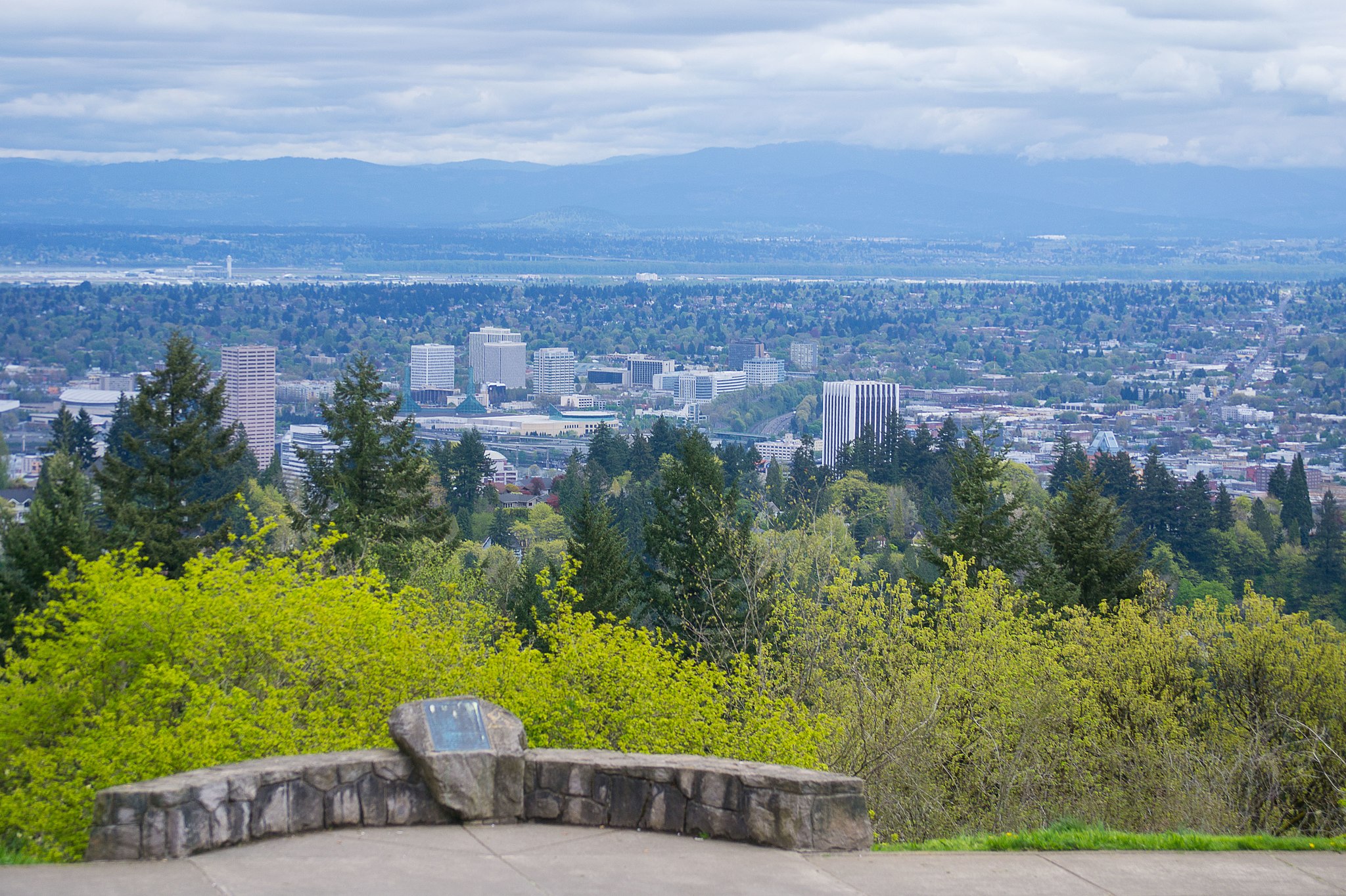
6. Southwest Hills Neighborhood
Southwest Hills neighborhood is unique in that it’s a stone’s throw from downtown Portland, yet is nestled in the densely treed, hilly streets of the west hills, also known as the Tualatin Mountains. It’s home to several parks and green areas, one of which is Marquam Nature Park. The neighborhood is also home to Council Crest Park, which offers some of the best views you’ll find in Portland. Southwest Hills is also in close proximity to Washington Park and all it has to offer, just across S. Sunset Highway via S. Canyon Road.
The western part of the neighborhood is outside city limits, and the northeastern portion is also referred to as Portland Heights.
Lifestyle in Southwest Hills is upscale and high-end. Homes here are well-built with top-quality finishes and custom features, many of which have gorgeous views of the city, Mt. Hood, and beyond. Southwest Hills is without a doubt, one of Portland’s finest in this regard.
Southwest Hills History
Southwest Hills is the site for one of the oldest and most notable homes in Portland, the 1918 Frank J. Cobbs House. While not much is found about the neighborhood’s history, it is said to have had a rocky beginning in the mid- to late-1800s, much like that of Arlington Heights (see below). The northern part of Southwest Hills neighborhood is referred to as Portland Heights. Any information found on the neighborhood’s development includes the entire area.
Referred to as the Tualatin Mountains before settlers arrived, the area was wild with thick forests and deep ravines. Trees were cleared and tossed into ravines, then filled to provide a foundation for the development and construction that would come. The Portland Railroad came to the area in 1890, which gave residents a way to reach Council Crest. Eventually, this location, which provides one of the best views of the city, was turned into a park with a restaurant and carnival rides.
The development and execution of this part of Portland was problematic because the ground was unstable due to the methods used to stabilize the ground, and sliding occurred. The area proved to be inaccessible until the Vista Bridge was constructed in 1903 over Turner Creek.
Once across the bridge, the ground was fairly flat and allowed for development into grid-like neighborhoods. Many of the original homes built during that time still remain: Victorians, Colonials, Foursquares, Old Portland, and a few Bungalows.
Despite the introduction of the railroad to the area, Southwest Hills development remained problematic, and things started to go downhill, literally. Sliding continued, moving homes and bending the train track rails. The first rail system lasted about fifteen years and was replaced by the streetcar system.
Without access to more details about this time in the neighborhood’s history, it’s hard to give a clearer picture than this. That said, though, it seems to mirror the history of Arlington Heights’ history found below.
Southwest Hills Restaurants, Bars, and Coffee Shops
Vista Spring Cafe—cozy joint serving up pizza and other Italian eats, plus American chow and booze in a woodsy setting.
Southwest Hills Points of Interest
- Governors Park—5.74-acre park space used for hiking and views.
- Marquam Nature Park—178.25-acre park with several miles of hiking trails.
- Portland Heights Park—A 5-acre city park offering sports fields and courts, an accessible play area, and paved and unpaved paths.
- Council Crest Park—city park with paved and unpaved paths, an off-leash dog area, picnic tables, public art, a view point, and a reservable wedding site.
- Jones Pioneer Cemetery—3.5-acre gem sitting high on a south-facing hill, with open lawns, views across the Tualatin Valley to the Chehalem Mountains, and walking paths under a canopy of trees.
Southwest Hills Rankings and Stats
- School—Ainsworth Elementary School – 9/10 / West Sylvan Middle School – 9/10 / Lincoln High School – 8/10 (by greatschools.com)
- Scores—Walk: 32 / Bike: 49 / Transit: 51 (by walkscore.com)
Search all Southwest Hills, Portland Homes for Sale
Check out our dynamic Portland neighborhood home search map.
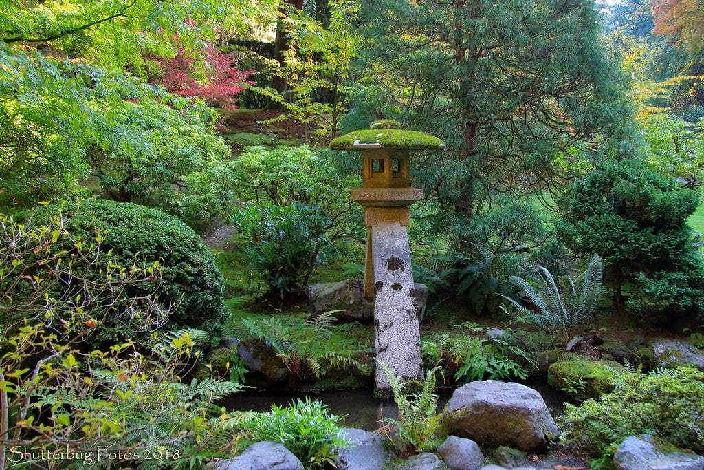
5. Arlington Heights Neighborhood
Like Southwest Hills, Arlington Heights is a neighborhood of steep, winding, tree-lined roads located in the Tualatin Mountains. This coveted neighborhood is peacefully surrounded by Portland’s Washington Park on three sides. Living in Arlington Heights means having the famed Japanese Gardens and Hoyt Arboretum, also within the park, right outside your door. Take a stroll in this lovely part of Portland, and you won’t believe you’re in an urban environment.
While there are other neighborhoods with higher walk and bike scores, one of the bonuses of living in Arlington Heights is the easy access to all the NW 23rd shops and to downtown Portland. It also boasts two highly rated schools.
Arlington Heights History
The history of Arlington Heights is storied with plenty of ups and downs in its development.
In 1851, when Portland became a city, the hill on which Arlington Heights sits was still wild and forested. By the 1890s, it was no longer a forest, due to logging that had occurred and to the Great Gale that blew through the area in January of 1880, toppling most of what fell in its path.
In 1845, Daniel Lownsdale opened his tannery along a creek in the southwest, which led to its name: Tanner Creek. He eventually sold his land claim to two men who left soon after for California, and the tannery was bought by Amos King, settler of King’s Valley.
King’s first concern was to keep the tannery in operation, so development of the area didn’t occur until sixty years later. The tannery was located in the area we now know as the stadium, and while running his operation, he also leased adjacent land to Portland’s Chinese community for growing vegetables.
Some time before 1860 (historic records are not clear), the Kings began to sell parcels of their land claim, the most notable of which was in February, 1871, when the City of Portland bought 40.79 acres and deemed it an area for park development and named it City Park. Today, we know this area as Washington Park.
The Gambrinus Brewery and Beer Garden came in 1878, located in the triangular-shaped section of the hill where W. Burnside (then called B Street) and NW Westover meet.
Two years before the Oregon Zoo was officially established in 1887, Charles M. Myers, the park’s head, tended to wildlife that lived there. The impetus for a zoo came when pharmacist Richard Knight brought a grizzly bear and an Alaskan bear to the city for children to view. By 1893, the collection of animals had grown significantly, and after Myers died in 1901, his duties were passed on to a man named Lowitz. In 1905 when Dr. Harry Lane became mayor, he posed that no other animals should be imprisoned, that no new specimens be brought in, and that those who were already on the grounds be allowed to live out their natural lives there.
When the King’s were granted their west half of the tract of land, federal law required that they split it in half between them. It wasn’t until Melinda’s death in 1887 that a clear boundary was drawn. In the fall of 1888, the King Real Estate Association (KREA), comprised of Amos King, his son, and his son-in-law, set out to plat and sell lots for homes and businesses. Melinda’s half of the area was deemed Melinda Heights. Drawing on the developmental success of nearby Portland Heights due to its accessibility via street car, the Kings decided a street car to the newly named neighborhood was in order. A new line that ran along Jefferson along 15th Ave to the park’s entrance was created.
However, the name of Melinda Heights never caught on but was referred to as King’s Heights by residents and on publicity for the new line. Ultimately, lots in this area failed to sell, and problems arose with the street car line due to structural issues, causing a caving in of the embankment built up across two ravines to accommodate the car and a subsequent bending in the tracks. Service to the area was seriously decreased and ultimately abandoned despite all the hype around the line.
In 1893, the city’s Water Committee bought sixty acres of the land next to Melinda Heights and began excavation for reservoirs and pouring concrete. Significant land sliding was noted shortly thereafter with cracks appearing in the concrete. No repairs were made to correct the problem, and in 1987, KREA filed a lawsuit, known as the “Sliding Land Trial,” against the City of Portland for damages to its Melinda Heights property, evidenced by sliding of homes, and the removal of the rail system, which was deemed unnecessary to an area not stable enough for dwellings. KREA also cited the resulting loss of revenue in light of the defunct rail system, which they claimed would have attracted people to the area.
Between 1901 and 1903, tunnels were built west of the reservoirs in the area to allow for water drainage, and the sliding the land had seen before had stopped. A year after landscape architect John Olmstead’s visit to Portland in May of 1903, during which time he gave recommendation about various parks in the Portland area, the reservoirs were filled in after requiring thousands of dollars in repairs and being non-operational for ten years.
In 1909, the city’s Water Board suggested that the Park Board utilize their sixty-acre tract of land for park development, cautioning about the need for close monitoring of the tunnels and surrounding land based on the previous issues. During this time, the sixty-acre tract and the adjacent historical portion of the area were named Washington Park.
New streetcar lines came and coincided with the establishment of businesses outside the downtown area. The 23rd line ran along Burnside, and in 1904, the Council Crest line started running from 23rd and Burnside. By 1911, they were running up the canyon as far as Mt. Calvary Cemetery, what some Portlanders referred to as the “funeral car.” In 1913, the Arlington Heights line was completed.
As far as historians can tell, Arlington Heights was a dead end for many years. No one is quite sure when the Fairview Blvd. through the Arboretum was built, but it was likely not before 1922 when the Poor Farm, a spot for Portland’s disadvantaged, became part of Washington Park.
Sparse population made it hard to justify the continued use of streetcar lines, so on March 8, 1941, the last street car made its run up the hill. The following day, bus service was used instead.
The first residents in Arlington Heights were John Bennes, an architect, and his family. They built their home at 122 SW Marconi St. From this time until 1919, only 19 houses were build in the neighborhood. Over the following ten years, about 100 homes were built, followed by a drop in construction brought on by the Depression. From 1930-1939, only 23 homes were built. Westwood Hills, adjacent to Arlington Heights, was platted in 1941, with 10 houses built before World War II, which ultimately halted construction. Only nine houses were built in the late 1940s with 25 in the 1950s, 27 in the 1960s, and 24 built in the 1970s.
In 1961, Kingston Rd. was built to accommodate growing traffic in and out of the Zoo. Today, the area welcomes thousands of visitors each year to the park, gardens, and arboretum.
Read more about Arlington Heights history.
Arlington Heights Restaurants
Umani Cafe—cafe located within the Japanese Gardens serving teas and desserts.
Arlington Heights Points of Interest
- Washington Park—410-acre park and crown jewel of Portland, home to the Oregon Zoo, World Forestry Center, Portland Children’s Museum, Hoyt Arboretum, International Rose Test Garden, and the Portland Japanese Garden.
- Japanese Gardens—authentic, 12-acre Japanese garden with eight garden styles, winding streams, gorgeous paths, and a breathtaking view of Mt. Hood.
- Hoyt Arboretum—190-acre ridge-top arboretum of 2,300 tree and shrub species from six continents and 12 miles of hiking trails.
- International Rose Test Garden—rrose test garden with over 10,000 rose bushes of approximately 650 varieties.
Arlington Heights Rankings and Stats
- School—Skyline Elementary School – 10/10 / Forest Park Elementary School – 9/10 (by greatschools.com)
- Scores—Walk: 35 / Bike: 58 / Transit: 53 (by walkscore.com)
See all Arlington Heights, Portland Homes for Sale
Check out our dynamic Portland neighborhood home search map.
4. Irvington Neighborhood
One of Irvington neighborhood’s most distinctive features is its excellent location for commuters getting to work and other nearby Portland neighborhoods. Freeway ramps to both I-84 and I-5, as well as Portland’s mass transit—the Trimet bus and MAX light rail systems—are easily accessible within Irvington and a few blocks away at Lloyd Center Mall, just south of the Irvington boundary.
Access to downtown and the Pearl District is made easy with a quick jaunt over the Broadway bridge. Likewise, Northeast to Alberta or Beaumont-Wilshire, northwest to the Boise/Eliot and Historic Mississippi Avenue neighborhoods, and southeast to the Belmont and Hawthorne neighborhoods are all mere minutes away. All this, and a highly ranked elementary school and excellent walk/bike scores, make Irvington a place where many want to live.
Irvington History
In its early existence, Irvington was part of the City of Albina (before Albina was annexed into Portland). Despite early industrialization and times of social unrest, Irvington has maintained its elegant character. But not without challenges.
Like virtually all of Portland, this area was first occupied by Confederated Tribes of the Grand Ronde, and the land was broken up and developed by the Donation Land Claim Act in 1852. The owner of much of Irvington’s donation land claim was Captain William Irving, a sea captain and ship builder.
When Irving passed away in 1872, his widow and son sold most of the land claim to Ellis B. Hughes, John W. Brazee, local businessman, and David B. Thompson, two-time mayor of Portland. Although the land was platted in 1874, it failed to sell because there was no streetcar service to the area, and there was cheaper land to be had in the Albina and East Portland communities. The owners sold the land in 1887, with development not occurring until 1890.
Land in Irvington started to sell consistently at the end of the century, mostly due to the need for housing for the city’s growing middle and upper classes, all while nearby Albina’s industrial base continued to grow.
Until its annexation with Albina and East Portland, Irvington was one of northeast Portland’s major recreation areas with horse and motor racing bounded by 7th, Freemont, Brazee, and 12th. What we now know as Irvington Park was a site for barns, grandstands, and landscaping.
Irvington land changed hands three times within a few years in the late 1890s and early 1900s. Economic wealth came to the area in 1905, thanks to the Lewis and Clark World’s Fair and Exposition. Three years later, the land was bought by Prospect Park Company with the intention to develop the area for upper class home owners. Eight acres were improved with sewer, water, gas mains, and hitching rings, along with asphalt streets and a luxury not found in other parts of the city: a network of concrete sidewalks. All this for a quarter of a million dollars—not a small amount of money for the time!
Having the highest elevation in the city, the neighborhood was billed as offering downtown and mountain vistas, however, the views were lost due to lots having been graded flat. So much for foresight!
By 1910, three streetcar lines ran between downtown Portland and Irvington. This increase in accessibility prompted more development, with photos of newly constructed homes featured weekly in the newspaper’s weekend edition.
Many of the homes standing today in Irvington on Hancock and Tillamook Streets between 7th and 25th Avenues represent the variety of residential architectural styles popular in the early 20th century: basic pioneer Victorians near 7th to high Craftsmans near 25th. You’ll find 1910s and 1920s apartments in between, built to accommodate the neighborhood’s density increase at the time.
The neighborhood maintained its opulence until after World War II when the building up of downtown and nearby Lloyd Center occurred. This development displaced many of the lower income residents from those areas and forced them into Irvington, which caused current residents to leave and property values to decrease quickly.
In 1964, the Irvington Community Association was formed in an attempt to stabilize the neighborhood and encourage residents still there to stay. This worked, but it wasn’t until the early 1970s Model Cities grant that rehabilitation and improvements happened.
To counteract the degeneration of the area between these years, which involved tearing down some homes and other structures, the Irvington Home Tour was created in 1967. The purpose of this tour was to revitalize interest in Irvington and resurrect its past presence as one of Portland’s more desirable neighborhoods. The tour remains today, and while there are a few condos in the Irvington, most residences are elegant single-family homes, restored to their original splendor.
Irvington Restaurants, Bars, and Coffee Shops
- Lucca Restaurant—wood-fired pizzas, pastas, and other classic Italian dishes served in a cozy, bustling dining room.
- Taste Tickler—long-standing eatery serving up sandwiches, Japanese bento boxes, and more in a bare-bones setting.
- Black Water Restaurant—happening nightspot with creative cocktails and pub eats with vegan options, plus live bands.
- Twisted Croissant—bakery reimagining the possibilities of croissant dough and providing handcrafted croissants, cruffins, and croissant donuts.
- Cadillac Cafe—neighborhood spot serving classic American breakfasts and lunches, with a vintage Cadillac on display.
- New 715 Inn—neighborhood watering hole with a pool table, video poker, and a low-key atmosphere.
Irvington Points of Interest
- Irving Park—16-acre city park located at Northeast 7th Ave. and Fremont St.
- Irvington Tennis Club—tennis club, established in 1898, listed on the National Register of Historic Places.
Irvington Rankings and Stats
- School—Alameda Elementary School – 8/10 (by greatschools.com)
- Scores—Walk: 84 / Bike: 99 / Transit: 62 (by walkscore.com)
See all Irvington, Portland Homes for Sale
Check out our dynamic Portland neighborhood home search map.
3. Grant Park Neighborhood
Grant Park neighborhood is named for the park at its center, a lovely and walkable green area spanning nearly 20 acres, serving the core of the neighborhood. The park houses a large outdoor pool, a community garden, and a dog park.
Grant High School, one of Portland’s highest rated schools, sits adjacent to the park and shares its up-to-date outdoor sports complex, dubbed “Grant Bowl,” with the public. Neighbors can watch the school teams play or join in on the fun themselves on the complex’s fields and tennis courts.
While the Grant Park neighborhood is mostly residential, it boasts close proximity to retail and dining. Within walking distance to Fred Meyer, Whole Foods, Trader Joe’s, and New Seasons, residents are ensured their choice when it comes to grocery shopping. If that weren’t enough, the Hollywood Farmer’s Market provides access to the best local produce, dairy, and crafts from the region every Saturday.
Grant Park is also a destination for many of Portland’s residents for many of its amenities. In addition to the Beverly Cleary Sculpture Garden in the park, there’s also a seasonal outdoor pool, a playground and fountains for young kids, sports courts and fields (basketball, baseball/softball, tennis, soccer), a running track, picnic areas, an off-leash dog area, and a community garden.
Established vegetable gardens and mature fruit trees in residential yards are common in Grant Park, as are poetry posts in front yards displaying artwork of the children who live there and classic poems. Some even have borrowing libraries outside for anyone walking by.

Grant Park History
Grant Park neighborhood is named after the eighteenth president of the U.S., Ulysses S. Grant, who visited Portland three times during his presidency.
Through a land claim donation known as the Bowering Tract, the neighborhood was partially settled in the 1850s. It consisted of a long, narrow strip of 160 acres from NE Fremont to Halsey near NE 33rd Avenue. The property then changed hands to Ellis Hughes, David P. Thompson, and John W. Brazee and was eventually sold to Charles Cardinell in 1887.
Fernwood Grammar School Campus, built in 1911, was renamed Beverly Cleary School in 2008 in honor of the children’s and YA author who was a Fernwood alumna.
Eliza Dolph, a descendent of Charles Cardinell, dedicated a section of Grant Park platted in August 1924, called Dolph Park, a subdivision of luxury homes. This section of the neighborhood remains demarcated within Grant Park today, marked by historic signs.
Grant Park Restaurants, Bars, Coffee Shops
- Blind Onion—lively joint for gourmet, specialty pizzas plus a variety of beers in a casual, basement-like space.
- Nicholas Restaurant—down-to-earth Lebanese eatery with a patio known for super-sized portions and fresh pita.
- Full Moon Thai—nothing-fancy local spot serving traditional Thai fare and booze. Also offers takeout and delivery.
- Coco Donuts & Coffee—bright, cheerful Portland chain shop offering crafted donuts and their own roasted coffee.
- Hale Pele—atmospheric tiki bar with lots of rum, artisanal syrups, a themed menu, and pufferfish decorations.
Grant Park Points of Interest
- Broadway Cigar Shop—upscale shop featuring premium cigars, lighters, accessories, walk-in humidor, TV, and a smoking lounge.
- Plants on Broadway—retail plant shop offering curated seasonal plants.
- Grant Park—19.9-acre park offering a play area, spray feature, picnic site, restrooms, and granite plaques engraved with the titles of the Beverly Cleary books, all set in the Grant Park neighborhood.
- Beverly Cleary Sculpture Garden—sculpture garden with bronze sculptures of author Beverly Cleary’s beloved characters Ramona, Henry, and Ribsy the dog, located within Grant Park.
Grant Park Rankings and Stats
- School—Grant High School – 9/10 (by greatschools.com)
- Scores—Walk: 84 / Bike: 98 / Transit: 61 (by walkscore.com)
See all Grant Park, Portland Homes for Sale
Check out our dynamic Portland neighborhood home search map.
2. Brooklyn Neighborhood
Uniquely shaped Brooklyn neighborhood’s residential area comprises only about half of its total land mass. Most of the western portion of it extends into the Willamette River and encompasses all of Ross Island, including Izzy’s Bay, and East Island.
Brooklyn takes on the hip, community-focused, family-friendly vibe of some of its bordering neighborhoods: Sellwood, Hawthorne, and Clinton. Here, you’ll find plenty of good coffee and lots of pub and dining options.
Spend a little time in this much-loved neighborhood, and you’ll see dog walkers, runners, and parents pushing strollers, along with others of all stripes, traversing its streets. You’ll also pick up on its fierce independence through the high number of locally owned businesses that thrive due to overwhelming local support.
Brooklyn History
The area marked as Brooklyn neighborhood today was initially inhabited by the Clackamas people. Giddeon and Mary Tibbetts were the first white settlers to acquire 680 acres of land through the Donation Land Claim Act of 1850. The land had been abandoned by the Dobbins family who left Oregon for California in search of gold. Tibbetts built his family home, the first one east of the Willamette River in the Portland area, in 1851. He also planted wheat across 40 acres, and made a gristmill, powered by Brooklyn Creek (previously called Brook Land creek), with business partner Robert S. Kinney.
Tibbetts originally named the area “Brook Land” in recognition of the creeks, river, and lakes on the property. In 1868, he allowed Ben Holladay’s Oregon Central Railroad to cross the property after subdividing the land. With the new rail line came new residents and the town square construction at Powell Blvd. and Milwaukie Ave. Eventually, the name transformed into “Brooklyn,” both for ease of articulation and as a nod to New York’s burrough.
By 1872, the tracks that ran from the Tibbetts farm, past Milwaukie and as far as Roseburg drew immigrants from southern Italy and parts of Germany looking for work. Italians and Scandinavians received most of the credit for laying the rails, however, it was Chinese laborers who were at the center of the development and beginnings of it all.
In the 1890s, Brooklyn saw an influx of Roman Catholic German-Americans. Remnants from that time remain today through several German-American businesses and the Johan Poulsen House, build in 1891, despite the changing of many original names during World War I.
The two-story wooden Brooklyn School at Haig and Milwaukie (now Brooklyn Park) was built in 1889, with two more wings added in 1915. Deemed a fire hazard by 1930, the new, brick Winterhaven School on SE 14th Street replaced it.
In the early 1900s, Brooklyn became a blue-color community with many more German businesses serving residents. In 1904, the first post office opened, one door north of what is now Aladdin Theatre.
Brooklyn also once had its own library (built in 1913) on the SE corner of Powell and Milwaukie where the Arco gas station now stands. It later moved to the fire station location on 12th and Powell, then to a location near Cleveland High School before it was closed in the 1930s due to lack of funds.
The Brooklyn Theater opened and offered movies from 1912—1929 and later became the lively Mission Dance Hall with live music and dancing. Isaac Geller, a Russian immigrant, opened the Geller Theatre, another movie house, and drew west-side residents by placing a huge neon sign atop his building. Geller Theatre was renamed Aladdin Theater in the 1930s.
Most of Brooklyn’s Victorian homes, Bungalows, and smaller workmen’s cottages were constructed with wood from the Inman and Poulson Lumber Company, one of the area’s largest lumber mills.
The face of this pristine neighborhood underwent remarkable change in the 1920s with the construction of Ross Island Bridge. This project demolished the town square and about a quarter of the neighborhood’s homes and shops. Streams and ponds were filled in, and the construction of McLoughlin Blvd. cut off access and connection with the Willamette waterfront. To add to this massive change, the neighborhood was also divided in two by the construction of the 17th Ave. overpass.
Brooklyn took a turn for the worse by the 1960s and developed major problems centering around crime, drugs, and poverty. Tom Potter, who would later become Portland’s mayor, was a beat cop at the time and became involved in BAC—Brooklyn Action Corps—to help combat the problems the neighborhood face. BAC was created by residents who wished to have more connection with City Hall and a louder voice in what happened in and to their neighborhood.
By the 1980s, Brooklyn had rebounded and today is thought of as one of Portland’s most desirable SE residential neighborhoods. The creation of the Eastbank Esplanade, constructed between 1998 and 2001, reconnected the neighborhood to the Willamette River, and the opening of the Orange Line light rail, completed in September 2015, has provided easier access to downtown and its amenities.
Despite all the changes Brooklyn has seen, it has endured and still retains much of its original charm.
Brooklyn Restaurants, Bars, Coffee Shops
- Coco Donuts & Coffee—bright, cheerful Portland chain shop offering crafted donuts and their own roasted coffee.
- Rose City Coffee—spacious joint featuring coffee drinks, sandwiches, and free WiFi in a bright, brick-walled setting.
- The Bear Paw Inn—mellow hangout providing happy hours and a large tequila selection, plus karaoke, pool tables & darts.
- Lotsa Luck Bar and Grill—neighborhood bar with affordable drinks and food.
- Eidelweiss Sausage and Deli—retailer of housemade sausages and charcuterie, and a wide range of European groceries.
Brooklyn Points of Interest
- Aladdin Theater—600-capacity venue that has won numerous awards as Portland’s favorite live music venue.
- Springwater Corridor—bicycle and pedestrian rail trail that follows a former railway line from Boring through Gresham to Portland and ends south of the Eastbank Esplanade.
- Ross Island Natural Area—main island of a four-island cluster, currently accessible only to individuals or small groups that volunteer for Portland Parks & Rec (PP&R), and for those organized by PP&R’s community partners: Audubon Society of Portland, Willamette Riverkeeper, and Urban Greenspaces Institute.
- Powell Park—8.09-acre public park offering a picnic area, restrooms, sport fields and courts, and paved and unpaved paths.
Brooklyn Rankings and Stats
- School—Winterhaven School (K-8) – 10/10 (by greatschools.com)
- Scores—Walk: 82 / Bike: 95 / Transit: 58 (by walkscore.com)
See all Brooklyn, Portland Homes for Sale
Check out our dynamic Portland neighborhood home search map.
1. Laurelhurst Neighborhood
Laurelhurst neighborhood came out on top for a number of reasons. Not only is this beautiful community lush with old trees, but it also boasts three highly ranked schools, high walk/bike scores, and a variety of eateries. All this and the gorgeous 26.81-acre Laurelhurst Park as its crown jewel.
One of Portland’s earliest planned neighborhoods, as opposed to some that grew organically, Laurelhurst offers loads of classic charm and an easy commute to downtown.
Laurelhurst History
Laurelhurst was part of the City Beautiful Movement in the early 1900s. A development of the Ladd Investment Company, owned by William Sargent Ladd’s heirs, it was purposefully platted to include winding streets to a creek bed for a public park.
The City Beautiful Movement arose from a widespread civic spirit and state of mind, a response to correct and redirect urban development practices. Portland’s leaders created a City Beautiful Fund at the time and, impressing on residents the importance of aesthetics and the preservation of nature, which grew through public subscription and funded the hiring of Edward H. Bennett, the man who devised the city’s first plan in 1912.
Drama ensued over the donation land claim by Elijah Davidson and Terrance Quinn, both of whom were some of the first to settle in the region but never made permanent improvements. The land went to their heirs, but they lost it due to questions of legitimacy regarding ownership. The land was then bought by William S. Ladd. Quinn’s daughter, Mary, challenged Ladd’s acquisition of the land after aging out of an uncle’s guardianship and being raised in a convent. The U.S. Supreme Court settled the case in favor of Ladd, and John Wesley Ladd, William Sargent Ladd’s son, received the deed in 1906.
Ladd expanded his holdings in 1873 and 1876 and built Hazel Fern, a 486-acre farm of purebred cattle, grain fields, and fruit orchards, and stretched occupied space between NE Halsey to SE Stark between 29th and 44th Aves. Ladd passed away in 1893. By then, residential subdivisions were sprouting up and growing within two miles of the farm’s furthest boundaries.
Deeming the land too valuable to remain farmland, William Ladd’s sons, Charles E., John Wesley, and William M., created the Ladd Estate Company and deeded Hazel Fern to William M., who created the Ladd Investment Company. The older Ladd’s estate was settled on May 26, 1908. On April 24 of that year, the tract was sold for $2 million, the largest sale of vacant land in Portland’s history at the time, as reported in The Oregonian. On May 24, the Laurelhurst Company was incorporated by four men—H. R. Burke and Charles K. Henry of Portland and Frank F. Mead and Paul C. Murphy of Seattle—to develop Hazel Fern for residential homes. Paul Murphy had been involved in Seattle’s Laurelhurst subdivision, so the name was given to the new Portland development site.
The Massachusetts architectural firm, the Olmstead Brothers, who had previously worked in both Seattle and Portland developing city-wide park plans and contributed to the site plan for the 1905 Lewis and Clark World’s Fair and Exposition in Portland, were hired to plan the development while maintaining the parameters set by the City Beautiful Movement.
Their primary intention in the planning phase was to develop a neighborhood with lush natural vistas that unfolded as the viewer traversed curving streets. Laurelhust Company took on the task of the neighborhood’s development and planted trees, established utilities, and paved over 52 miles of sidewalks and 26 miles of streets after platting 2,800 lots. During this time, tracts were set aside for an elementary school, a 32-acre park, and the Mann House, a safe home for women.
Building restrictions were then put in place, which consisted of designating only single-family homes costing no less than $3,000 to be built, excluding stores and apartment buildings. Other restrictions included the making or selling of alcohol and selling to Portland’s Chinese, Japanese, and Black residents.
During this same period, the Ladd Investment Company deeded an area on Glisan Street for what would become the Montavilla streetcar line, an important part of Laurelhurst’s development, as the automobile had yet to become front and center in residents’ daily lives.
Homes that were built sold fast, the first being constructed by W. N. Everett at 825 NE Hazelfern Pl. By 1910, about half of the lots had been sold with one of the biggest selling points of the neighborhood being the park and the atmosphere it created, including Laurelhurst Club and its tennis courts.
One section of Laurenhurst during this time—surrounded by Burnside, SE Ash, and 41st and 43rd Aves.—was deemed a “bungalow fairyland.” By 1925, nearly all lots had been built on.
In 1919, four streetcar lines carted residents to and from the neighborhood: East Ankeny, Montavilla, Rose City, and Beaumont. The Sunnyside and Mt. Tabor lines served those on the north end of the neighborhood.
To this day, Laurelhurst maintains its distinct identity with non-residential zoning kept to a minimum, except for the northwesternmost corner along Sandy Blvd. The sales office responsible for moving the lots and the development of Laurelhurst, including the approximately 1,000 bungalows from the early 20th century building surge, was removed and replaced with the statue of Joan of Arc in 1925. The sandstone pylons that mark entry to the neighborhood are all that’s left from the gate that once designated its high exclusivity.
Laurelhurst Restaurants, Bars, and Coffee Shops
- Chit Chat Cafe—bubble tea, smoothies, and light meals like bento boxes and bagel sandwiches in a casual cafe setting.
- Petite Provence Boulangerie & Patisserie—local bistro chain serving French fare, breakfast, baked goods, and drinks in a relaxed, stylish space.
- Chopsticks—hopping bar offering nightly karaoke and Chinese-American fast food, plus pool tables and a patio.
Laurelhurst Points of Interest
- Piconne’s Corner Butcher Shop—local butcher bringing Portland in closer contact with the food they eat and the farmers who produce it.
- Ash Street Wine Co.—A négociant winery partnering with small-lot winemakers to bring people together with their essential dinner party wines.
- Laurelhurst Club—Modernized, light-filled Craftsman-style club, a picturesque venue for important events.
- Rose City Baseball Club—Local baseball club providing a higher level of instruction and skill development than found in recreational setting.
- Coe Circle—A park, of sorts, presented as a roundabout in the center of the neighborhood, displaying a bronzed stature of Joan of Arc.
- Laurelhurst Park / Firwood Lake—32.27-acre historical site city park with a sports courts (basketball, tennis, and volleyball), a soccer field, picnic areas, a playground, an off-leash dog area, a horseshoe pit, public art, a stage, and public restrooms.
- PulsePDX—fitness center offering Zumba, POP Pilates, U-Jam, and other classes in a dance-club setting.
Laurelhurst Rankings and Stats
- School—Grant High School – 9/10 / LeMonde French Immersion Public Charter School – 8/10 / Laurelhurst (Elementary) School – 7/10 (by greatschools.com)
- Scores—Walk: 82 / Bike: 94 / Transit: 65 (by walkscore.com)
See all Laurelhurst, Portland Homes for Sale
Check out our dynamic Portland neighborhood home search map.
Top 1% Portland Buyers Team Wants to Talk!
If you’re thinking of a moving to one of these fantastic Portland neighborhoods, or anywhere in the greater metro, our top 1% Portland buyers team wants to talk with you today. Call us at 503-773-0000 or chat with the bot on our site.
Article Sources:
Beck, Dana. “Brookland became Brooklyn and rails appeared, as a neighborhood formed.” The Bee. Pamplin Media Group, May 1, 2012.
Brooklyn. Wikipedia.
Hofman, Jane R. Neighborhood in the Park, The: The History of Arlington Heights, 1979.
Goose Hollow Foothills League. Goose Hollow History. Goosehollow.org.
Grant Park Neighborhood Association. Grant Park.
Killen, John. “Throwback Thursday: Cable railway system opened door to Portland Heights.” oregonlive.com, January 9, 2019.
Mt. Tabor Neighborhood Association. Mt. Tabor.
Mt. Tabor. Wikipedia.
Potential Historic Conservation Districts. Portland Historic Landmarks Commission and Portland Bureau of Planning. 1978.